What date will the road re-open?
We can now confirm that the road will re-open to the public on Friday, 17 July, 2026.
Where is the landslip exactly?
The landslip occurred on a narrow section of the A592 at High Kingate, just north of Troutbeck and before the A592 becomes Kirkstone Pass.
What3words location: epidemics.ghosts.treaties
What happened to cause the landslip?
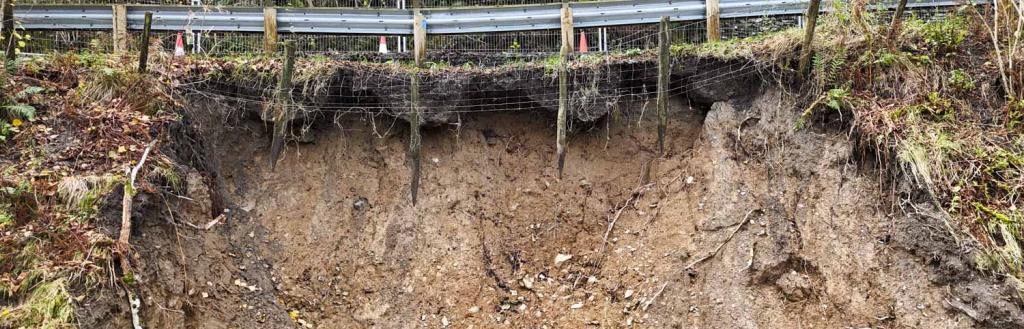
A section of the steep banking alongside the A592 at High Kingate slipped, undermining the carriageway, following heavy rainfall in November last year.
A large amount of the hillside dropped down the banking into the valley below.
This created a void under the road and the road safety barriers at the edge of the road were left hanging in the air.
There is a considerable elevation difference on this section of slope and due to the weather there was an ongoing risk of further deterioration.
Following the landslip, the council’s highways team put in place an emergency road closure and installed barriers to prevent people trying to use the closed section, while continuing to allow farmers and local landowners access to their fields.
Measures were immediately taken to stabilise the ground and divert water away from the landslip site to prevent further collapse.
How has the repair been carried out?
The repair works involved a combination of ground stabilisation, structural support, and improvements to drainage and road safety features.
In summary, the works included:
- Removal of failed and weakened material, which has been replaced with a stable granular fill to restore strength to the slope.
- Strengthening of the ground and embankment using steel reinforcement bars (known as soil nails) installed into the slope and secured with grout. A flexible steel mesh has then be applied to help stabilise the surface, followed by topsoil, seeding, and erosion control matting to encourage vegetation growth.
- Construction of a new low height retaining wall faced with natural slate to replace the existing highway verge and upper embankment.
- Localised replacement of the existing safety barrier with a slate faced masonry parapet where required.
- Repair and renewal of sections of the highway surface water drainage system to improve water management and reduce future erosion.
- Localised repairs to other smaller areas affected by minor erosion or scour, including strengthening around existing retaining walls.
These works are designed to improve slope stability, protect the highway, and reduce the risk of future damage.
Has any additional work been carried out while the road was closed?
While the road was closed for the landslip repairs, the council’s highways teams also took the opportunity to carry out some other maintenance/defect works on this stretch.
This included drainage repairs, inspection and stabilisation works to the rock face at Raven Crag, infilling scour voids, repairing potholes and removing invasive Himalayan Balsam and some trees affected by Ash dieback.
How long have the works taken to complete?
The works have taken approximately 12 weeks to complete.
The appointed contractor mobilised on site on the 22 April following the return of ecological surveys and completion of design works.
The intention was always to complete the works to allow the road to re-open ahead of the main school summer holiday period and key tourist season.
What impact did this have on communities and businesses, particularly in the Ullswater Valley?
We have recognised the closure resulted in inconvenience for communities and has had impacts on businesses either side of the closure, particularly hospitality businesses.
The council worked with Cumbria Tourism to share messages that communities remained ‘open for business’ during the closure and we held briefings with parish councils in affected areas and kept key stakeholders updated as things developed.
We set an ambitious target to get the road re-opened for the start of the busy school summer holidays to ensure those businesses could be fully accessible during the peak tourism season.
We are assessing whether any public rights of way alongside and down into the valley could be suitable as an alternative route around the closure for cyclists.