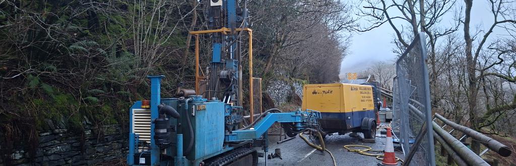
Specialist technical consultants have been hard at work carrying out assessments to determine the best way to repair a significant landslip that has closed part of the A592 at High Kingate.
Westmorland and Furness Council used emergency procurement processes to move quickly to engage the expert teams in early December. Thanks to relatively favourable weather conditions, they have already managed to complete ground investigation surveys on the carriageway above the landslip area before Christmas, and a full drainage survey has also now been completed.
The next stage will involve the removal of the crash barriers at the landslip location and moving ground investigation surveys to the steep banking below the carriageway. This will involve the installation of temporary soil nails by a specialist contractor.
Alongside ongoing topographical surveys, the results of laboratory tests on the ground investigation samples will determine the preferred engineering solution to carry out repairs.
Subject to completion of these surveys and laboratory tests, it is hoped that by by mid-February there will be a clear recommendation how best to proceed, so repair work can be safely carried out on the narrow, restricted site, which has steep banking above and below, to enable the route to be re-opened as quickly as possible.
An emergency road closure was put in place on the A592 approximately halfway between Troutbeck and the Kirkstone Inn at High Kingate, just before the start of the Kirkstone Pass, following the landslip, which was caused by heavy rainfall.
The landslip has partly undermined the carriageway and the constraints of the site and the winter weather conditions mean carrying out the repairs will be challenging and take several months to complete.
Now the specialist technical consultants have started work it is hoped a more detailed timetable can be confirmed once they have completed the investigations and made recommendations on the potential repair methods.
Following the landslip on 5 November, the council’s highways team put in place an emergency road closure and installed barriers to prevent people trying to use the closed section, while continuing to allow farmers and local landowners access to their fields.
Measures have already been taken to try to stabilise the ground and divert water away from the landslip site to prevent further collapse.
Signs advising of the closure and the designated diversion routes have been put in place along all main routes leading up to the A592. The towns and villages either side of the closure are still fully accessible via the diversions and nowhere is cut off.
In addition to the regular signs, six electronic ‘matrix’ signs have been brought into the area to support messaging about the closure and that local businesses are still accessible.
This includes matrix signs at the top and bottom of The Struggle – a steep and narrow local road that runs from Ambleside to the top of Kirkstone Pass.
For the official diversion routes around the landslip closure the council can only sign along main routes, that can be accessed by the majority of vehicles. For that reason, The Struggle does not form part of the official diversion route as it has a 6’ 6” width restriction and, as the name suggests, it is very steep and at several points is very narrow and therefore not suitable for larger vehicles, especially in poor weather/winter conditions.
The council recognises that many locals will continue to use this route during the emergency closure and gritting teams will be treating The Struggle during the winter months during daylight hours only, to maintain this link between communities either side of the landslip. However, the council is not promoting The Struggle as an alternative route and drivers are reminded that this road will be challenging and potentially impassable in the winter months.
The additional matrix signs at the top and bottom of The Struggle will carry messages about width restrictions and the unsuitability of the route for larger vehicles. The signs will also advise when gritters are treating the route, asking drivers to wait until the gritting wagon has completed its run to avoid the risk of blocking the road. For the same reason, drivers are also requested to not use designated passing places on The Struggle for parking or for overnight stays.
Utility companies have a legal right to undertake works on the council’s road network, but the council manages and co-ordinates works through a permit system to try to minimise disruption. The council doesn’t have the power to ‘ban’ all works on the road network in the area around the A592 closure and urgent works – for example to repair a water or gas leak – may still need to be carried out by utility companies.
The council has contacted utility companies to advise them of the landslip issue and to ask them to consider postponing or rescheduling routine or pre-planned works on the diversion route while the A592 closure is in place to avoid further pressure on these routes. The council itself is also looking to reschedule any planned routine works on these parts of the network.
Wherever possible, the council will look to ensure any urgent or essential works that have to be carried out at this time will be done under traffic light controls rather than full closures to minimise further disruption.
Local parish councils and businesses have been updated on the landslip works and the council is working with Cumbria Tourism to help promote the message that areas around the closure, including Kirkstone Pass itself and villages in the Ullswater Valley, are still accessible and very much still ‘open for business’.
- An FAQs document answering more questions about the landslip and information about diversion routes
- Drone footage showing the extent of the landslip: https://youtu.be/m87Di5a_Up0